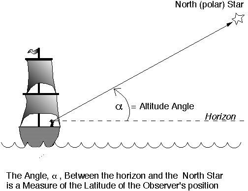
Latitude is determined by measuring the angle from the horizon to a pole star (a star that lies along the line of the Earth's axis). To find the pole star, look for the star around which all the others rotate. In the Northern Hemisphere, this is the North Star (Polaris); in the Southern Hemisphere, look for the Southern Cross constellation. Your latitude will be equal to the angle between the horizon and the pole star. If you are seeing the North Star, your latitude is north of the equator, and if you see the Southern Cross, your latitude is south of the equator.
[This image was created by Ted Moore at the University of Michigan]
Longitude can be calculated easily if you have an accurate clock set to Greenwich Mean Time (GMT, equivalent to English time). To do this, you need to do the following measurements and calculations:
Problem: While studying one summer at the British Museum in London, you have been kidnapped, drugged, and abandoned on a desert Island. When you come to, you find that your captors have left you with your Rolex watch (a fine chronometer) and a sextant. If you can only find out where you are, you might be able to find a way home. Using the sextant you discover that the North Star is 19° above the horizon at dusk. The next day you find that when the sun appears to reach its highest point, your watch reads 4:30 PM.
Questions:
Where are you? (What ocean, what latitude and longitude?)
What is the nearest land?
Solution:
Latitude: The angle between the horizon and the pole star gives you your latitude (19°) and because it's the North Star, you must be at 19°N.
Longitude: At local
apparent noon (when the sun reaches its highest point in the sky) the time that you read from your watch
is 4:30 PM. The time difference between your position and jolly old England - assuming that your
captors have not reset your watch - is 4 hours 30 minutes, or 4.5 hrs. England has reached its local noon ahead of you, so you must be to the west of it. To calculate how far to the west, you remember that the
earth rotates 15° of longitude every hour. You estimate that you are located on the 67.5° (15°/hour times 4.5 hours)
meridian of longitude.
Answers: Position 19°N, 67.5°W in the Atlantic Ocean near Puerto Rico.
[This problem slightly modified from an original by Ted Moore at the University of Michigan]